The lesson learned last night is that a tsunami threat is real for Belize and that people need to have a tsunami evacuation plan set in place. There was widespread panic along the coastal communities of the country, in particular on the islands.
After experiencing strong tremors due to a 7.8 magnitude earthquake that was centered 125 miles (202 km) northeast of Barra Patuca in Honduras, Belizeans were warned of a possible tsunami. The Pacific Tsunami Warning Center initially warned that tsunami waves up to 1 meter (3 feet) above tide level could hit parts of Honduras, Belize and Puerto Rico along with the U.S. and British Virgin Islands.
Hon. Edmond Castro, Minister of National Emergency Management, spoke on local radio to urge people living in low lying coastal areas and islands to stay alert for potentially dangerous waves. People were prompted to seek shelter in higher ground and move up to, at least, a two story building.
Tsunami Warning Lifted for Belize
About two hours after the quake, the Minister of National Emergency Management reported on National Media, as of 11:00 PM, that the Pacific Tsunami Warning Center had lifted the Tsunami Warning for the nation of Belize.
“Of critical concern now is the state of our bridges in the aftermath of the earthquake,” stated the Minister of National Emergency Management after the “All Clear” was announced. “Before vehicles, particular buses and heavy trucks, cross any of our bridges, it is important that those structures are inspected by the Ministry of Works or Transport Department to ensure that they are structurally sound and safe.”
NEMO advised the public to remain vigilant throughout the night and into the morning, and to keep monitoring the radio and other media outlets for further information.
There were not yet reports of injuries resulting from the quake, thanks to its location in the middle of the sea far from any populated areas. The Caribbean is a seismically active region; this was the strongest quake in the region in almost two decades. By comparison, the devastating Haiti earthquake was a 7.0 magnitude on the Richter scale.
*Some residents along the coast were clueless as to what precautionary measures to take and were running to the shore to check on the sea water levels.
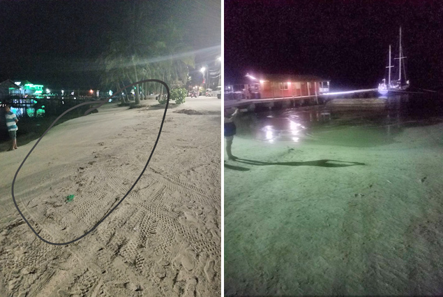
*There were reports of water receding on Ambergris Caye, Caye Caulker, Corozal Town and even neighboring Chetumal, Mexico; Some were attributing it to a low tide only.
* San Pedro High School, on Ambergris Caye was opened as a shelter and any tourist and locals took shelter there for a couple hours.
*Videos on social media showed long lines at gas station in Belize City as people planned on moving more inland to higher ground.
*At the cayes, residents with boats planned on heading out to sea to avoid any possible waves, while others just went to secure them.
*Planes were heard circling the island as local airlines evacuated their aircrafts to the mainland.
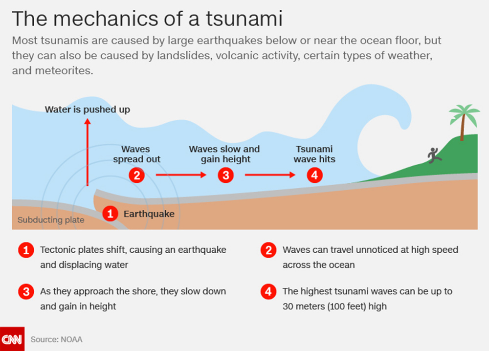
The Mechanics of a Tsunami

Remember that whenever the sea is receding in the wake of an earthquake, a tsunami is possible. In such circumstances, people along the coast are advised to move away from the sea, seek higher ground, move to the second story of a building, stay away from glass windows, turn off butane tanks and all gas valves.
In the event of an earthquake, if you are outside when it strikes, stay outside; if you are inside, go under a sturdy structure or piece of furniture, or move to a corner of the building you are occupying. Tsunamis can travel over 800 kilometers per hour (500 miles) at the deepest point of the water, but they slow as they near the shore, eventually hitting the shore at around 30 to 50 kph (20 to 30 mph). The energy of the wave’s speed is transferred to height and sheer force as it nears shore.


