Crown Weather Service says “BUCKLE UP” as it looks like it’s going to be an extraordinarily active hurricane season in terms of both number of storms and also in the amount of potential impacts across the Caribbean and along the US Coastline (especially the Gulf Coast). According to the weather forecasting service, the combination of developing La Nina conditions this summer and well above average ocean temperatures across the deep tropics is likely to lead to an extremely busy hurricane season.
The mean storm track this hurricane season will be further west than last year which means that the Caribbean, the southwest North Atlantic (near the Bahamas and Florida) and the Gulf of Mexico could be particularly at risk.
- THE NUMBERS: 25 Named Storms, 12 of those storms becoming Hurricanes and 6 of those hurricanes becoming Major Hurricanes (Category 3 or higher on the Saffir-Simpson scale). Not only will it be a hyperactive season, but also the forecast puts this upcoming hurricane season in the top ten of the most active hurricane seasons on record.
- ENSO CONDITIONS: The current El Nino conditions are rapidly weakening with cooler than average waters now showing up in the eastern Pacific. It seems quite likely that the ENSO conditions will become ENSO neutral sometime during April and then become La Nina conditions during about the July and August time period.
This reversal in ENSO conditions means that it will most definitely enhance tropical storm and hurricane activity across the Atlantic Basin this season with well above average amounts of activity in terms of the number of tropical storms and hurricanes.


- SEA SURFACE TEMPERATURES: Once again, the lack of any real winter this year has significantly affected the ocean water temperatures across the North Atlantic and the Gulf of Mexico with well above average temperatures almost everywhere.
Of particular note is the eastern Tropical Atlantic where both ocean water temperatures and ocean heat content are in record warmth territory. In fact, the ocean temperatures over the eastern Tropical Atlantic are as high as what you would normally expect them to be during mid-June.
The latest climate models suggests that well above average ocean water temperatures will remain locked across the deep tropics leading to the potential for a very active season in the deep tropics with “classic” long track Cape Verde storms very much on the table.
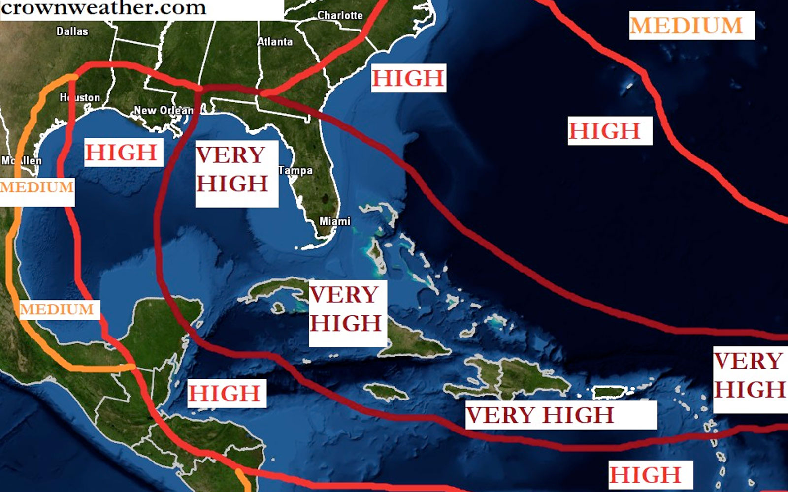
- LANDFALL THREAT FORECAST: There are two areas of most concern for this upcoming season in terms of a tropical storm or hurricane impact. The first area is the Caribbean and in particular the northeastern Caribbean and the northwestern Caribbean. The extremely warm ocean temperatures over the deep tropical eastern Atlantic combined with the developing La Nina conditions and a upper level weather pattern that features a big Bermuda high pressure system to the north means long-track tropical storms and hurricanes will be a big, big threat.
Last Hurricane to Hit Belize – LISA 2022
The northeastern Caribbean, including the northern Leeward Islands, the Virgin Islands and Puerto Rico could be at significant risk this season. Also in potential threat are the islands of the northwestern Caribbean, including the Cayman Islands, the northeastern Yucatan Peninsula and western Cuba could also be at significant risk this season.
The second area of particular concern is a corridor from the Bahamas through the Florida Peninsula to the eastern Gulf of Mexico. According to Crown Weather Services, the main storm track this season will be further west than last year, which means that many of the storms will be passing through the Bahamas and the Florida Peninsula. The eastern Gulf of Mexico may be affected in two ways – one by systems moving westward from the Bahamas and two by any systems moving northward from the Caribbean.
Other areas of concern include the central and northwestern Gulf coast and the southeastern coast of the United States where tropical activity may be drawn northward up the East Coast of the United States from the northern Caribbean islands or pulled northward into the Gulf of Mexico from the Caribbean.
Another area to closely monitor is the central and southern Lesser Antilles and Barbados where Cape Verde storms may impact on their track westward.
Even though your area may have a low or medium risk this season, be aware that any small fluctuations in the upper level weather pattern at the “wrong” time could threaten the low or medium risk areas. As always, it is best to keep informed and well-prepared this hurricane season.
(source: Crown Weather Services)